Garden with Insight v1.0 Help: Simulation options window: soil general panel
In the simulation options window, the soil general panel contains the
following items. Click on the Soil general button at the bottom of the window to see the soil
general panel.
Default soil type
Changing the default soil type will change the soil type that appears in the Soil patch basic parameters window when you create a new soil patch.
Click the ellipse  button to open
the templates window and import soil types from an outside library. button to open
the templates window and import soil types from an outside library.
The check boxes in the remainder of the Soil general panel control whether various processes are carried
out by the model every day of the simulation. If an option is
checked, the process is turned ON for all soil patches, overriding any individual settings.
This is the default when you create a new garden. If an option is unchecked, the process
is turned OFF for all soil patches. If an option is grayed (filled in but
not checked), settings in individual soil patches are used for the option. You can change options for
individual soil patches in the browser (see the Soil params options group). By default each soil patch has
all processes turned on when it is created.
General
Soil cover index updating: Check to recalculate the soil cover
index every day; or uncheck to 'freeze' the soil cover index at the last calculated value. The soil cover
index is the fraction of the soil's surface covered by vegetation (alive or dead). [how soil cover index works]
Albedo updating: Check to recalculate soil albedo every day;
or uncheck to 'freeze' the albedo at the last calculated value. Albedo is an estimate of the reflectivity of the
soil surface to the sun's radiation. [how albedo works]
Soil temperature updating: Check to recalculate the temperature of each soil layer every day; or
uncheck to 'freeze' the temperature of each soil layer at the last calculated value. [how soil temperature works]
Water balance
Snowmelt: Allow snow on the soil surface to melt and run into the soil. [how snowmelt works]
Precipitation: Allow precipitation to reach the soil patch surface and enter the soil patch.
Percolation: Allow water to percolate downward through the
soil. [how percolation works]
Lateral flow: Allow water loss from the soil by lateral
(horizontal) subsurface (under the soil surface) flow. [how lateral flow
works]
Soil evaporation: Allow water at the soil surface to evaporate
and be lost from the soil. [how evaporation works]
Plant transpiration: Allow plants to pull water from the soil through transpiration. [how transpiration works]
Water table depth updating: Check to recalculate the depth of the water table every day; or
uncheck to 'freeze' the water table depth at the last calculated value. Water table depth is affected by daily
rainfall, with some lag for the buffering effects of the soil. [how water table
depth works]
Soil settling from rain: Allow the soil to settle after each rainfall. [how soil settling works]
Runoff and erosion
Runoff from precipitation: Allow water to run off the soil surface
when it rains and the soil is saturated with water. If this option is turned off, the water will remain in the
soil although the soil could not possibly hold it in reality. [how runoff from
precipitation works]
Runoff from irrigation: Allow water to run off the soil surface when the soil is irrigated and the
soil is saturated with water. If this option is turned off, the water will remain in the soil although the soil
could not possibly hold it in reality. [how runoff from irrigation works]
Water erosion from precipitation runoff: Allow soil to be lost through sediment carried with
water that runs off the soil surface from rainfall. [how erosion from
precipitation works]
Water erosion from irrigation runoff: Allow soil to be lost through sediment carried with water
that runs off the soil surface from irrigation. [how erosion from irrigation
works]
Wind erosion: Allow soil to be lost through wind erosion. [how
wind erosion works]
Settle furrow dikes after rain: Allow furrow dikes to settle, reducing their water-holding
capacity, after each rain. Furrow dikes are raised ridges that keep rainfall from running off while the soil
is saturated to control water runoff and erosion.
Organic matter
Standing dead plant residue decay: Allow standing dead plant matter (above the soil) to decay to flat
residue (in the soil). [how residue decay works]
Flat residue decay: Allow flat residue in the soil layers to decay. Part (40%) of decaying flat
residue returns to the atmosphere (as methane and other gases). The rest moves into organic matter, the
most decayed carbon component in the soil layers.
Flat residue loss in sediment: Remove a quantity of flat residue from the first soil layer
proportional to the amount of soil lost from that layer during erosion. (This is not in EPIC and was added
by us.)
Organic matter loss in sediment: Remove a quantity of organic matter from the first soil layer
proportional to the amount of soil lost from that layer during erosion.
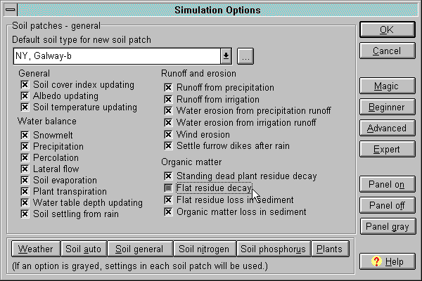
The simulation options window with soil general panel
See also:
How to change the default soil type
| 